
Trusted Hydrographic & Coastal Survey Services since 1998 | A DNV Company

I need a harbour port marina bathymetric depth water storage curve river bank harbour wall lost anchor dredge works survey

Trusted Hydrographic & Coastal Survey Services since 1998 | A DNV Company

We provide a full range of bathymetric, geophysical, LiDAR and coastal survey services – from ports and harbours to rivers, reservoirs, and open coastline so our clients can operate and navigate safely and responsibly.

WHO WE ARE

1

Shoreline Surveys is a specialist hydrographic and coastal survey company, part of the DNV Group, delivering precision data across the UK since 1998.
2

We provide multibeam bathymetric, geophysical, LiDAR, and coastal survey services - from ports and harbours to rivers, reservoirs, and open coastline.
3

We work with port authorities, harbour masters, local councils, environmental agencies, engineering consultancies, and water utilities across the South West and nationally.

We Deliver Landmark Projects

With over 3,000 projects completed since 1998, Shoreline Surveys has built a reputation for delivering clean, well-managed survey programmes from mobilisation through to final data delivery. We operate nationally from our South West base, working across ports and harbours, coastal and nearshore environments, inland waterways, and reservoirs – adapting our methods and equipment to the demands of each project.

Our team brings decades of hydrographic experience to every commission, backed by the resources and quality standards of Ocean Ecology & our parent company, DNV. Whether you need a one-off bathymetric survey or an ongoing monitoring program, we manage the process from start to finish – on time, to specification, and without fuss.

OUR SPECIALISMS

TRUSTED BY

WHAT WE OFFER

The golden standard in underwater depth mapping, multibeam sonar delivers full-coverage, high-resolution seabed data in a single pass. Essential for dredge planning, navigational safety, and hydrographic charting, our multibeam surveys produce accurate, georeferenced outputs processed to client specification. Ideal for port authorities, harbour masters, marine contractors, and coastal engineers.

A proven, cost-effective solution for depth profiling along defined transects in rivers, reservoirs, marinas, and sheltered coastal waters. Single beam echo sounding remains the go-to method for routine monitoring, pre-dredge assessments, and smaller-scale hydrographic surveys where full multibeam coverage is not required. Suited to water utilities, local authorities, marina operators, and inland waterway managers.

Side-scan sonar produces detailed acoustic imagery of the seabed, revealing obstructions, debris, scour, and seabed texture across wide survey corridors. A critical tool for obstruction detection, cable and pipeline route surveys, and pre-construction site investigation, it delivers the seabed intelligence that clients need before committing to marine works. Widely used by marine contractors, utilities, port operators, and environmental consultancies.

Sub-bottom profiling penetrates the seabed to reveal sediment layering, buried infrastructure, and geological stratigraphy beneath the waterline. A vital componenent of geotechnical investigation, dredge assessment, and cable route planning, it gives clients a clear picture f subsurface conditions before costly marine operations begin. Typically specified by marine engineers, geotechnical consultancies, energy developers, and dredging contractors.

Combining side-scan sonar, sub-bottom profiling, sediment sampling, and magnetometer survey into a single integrated campaign, geophysical surveys provide a comprehensive characterisation of the seabed and its subsurface. From UXO risk screening and pipeline route assessment to environmental impact baseline work, our geophysical packages are tailored to project requirements and regulatory needs. Commissioned by offshore developers, infrastructure contractors, environmental consultancies, and government agencies.

Unmanned aerial survey delivers rapid, high-resolution topographic data across coastal, riparian, and hard-to-access environments with minimal ground disturbance. Using photogrammetry and drone-mounted sensors, we generate accurate orthomosaics, elevation models, and volumetric data to compliment hydrographic survey campaigns. A practical solution for coastal engineers, flood risk consultants, local authorities, and asset managers needing fast, accurate spatial data.

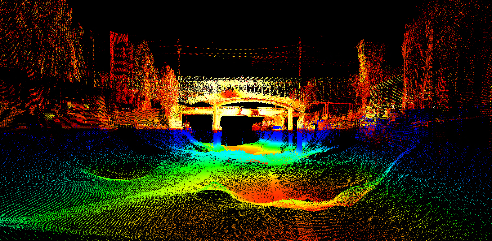
Vessel-mounted LiDAR captures precise, georeferenced point cloud data of coastal structures, cliff faces, bridge soffits, and intertidal topography from a stable waterborne platform. Combining the reach of a survey vessel with the resolution of laser scanning, it fills the gap between traditional hydrographic and terrestrial survey methods. Particularly valuable for coastal engineers, infrastructure asset managers, port operators, and flood risk specialists.

The coastal and nearshore zone is one of the most technically demanding survey environments – tidal, shallow, dynamic, and often inaccessible by conventional means. Shoreline’s specialist capability in this environment spans bathymetry, LiDAR, geophysical, and monitoring surveys, delivering integrated datasets that support coastal management, planning, and engineering decisions. Our clients include local authorities, coastal engineers, environmental consultancies, the Environment Agency, and government bodies managing the UK’s coastline.

From highland reservoir to tidal estuary, our inland hydrographic surveys deliver the depth data, sediment intelligence, and channel geometry needed for flood modelling, asset management, and dredge planning. We work to the standards required by the Enviornment agency, water utilities, and infrastructure owners, producing outputs compatible with hydraulic modelling software and GIS platforms. clients include water companies, the Environment Agency, local authorities, canal and river trusts, and civil engineering contractors.

Raw survey data only has value when it is accurately processed, quality-assured, and presented in a format that clients can actually use. Our in-house processing and reporting capability ensures that every dataset we deliver – whether bathymetric, geophysical, or LiDAR – is clean, validated, and accompanied by clear, professional reporting. We work to agreed client formats and industry standards, supporting engineers, planners, environmental consultants, and project managers who need reliable data to underpin critical decisions.

Our services

Shoreline Surveys is a specialist hydrographic and coastal survey company.

We are not a generalist practice – everything we do is focused on the water environment, giving our clients the depth of expertise and equipment capability that generalist surveyors cannot match.

The golden standard in underwater depth mapping, multibeam sonar delivers full-coverage, high-resolution seabed data in a single pass. Essential for dredge planning, navigational safety, and hydrographic charting, our multibeam surveys produce accurate, georeferenced outputs processed to client specification. Ideal for port authorities, harbour masters, marine contractors, and coastal engineers.

A proven, cost-effective solution for depth profiling along defined transects in rivers, reservoirs, marinas, and sheltered coastal waters. Single beam echo sounding remains the go-to method for routine monitoring, pre-dredge assessments, and smaller-scale hydrographic surveys where full multibeam coverage is not required. Suited to water utilities, local authorities, marina operators, and inland waterway managers.

Side-scan sonar produces detailed acoustic imagery of the seabed, revealing obstructions, debris, scour, and seabed texture across wide survey corridors. A critical tool for obstruction detection, cable and pipeline route surveys, and pre-construction site investigation, it delivers the seabed intelligence that clients need before committing to marine works. Widely used by marine contractors, utilities, port operators, and environmental consultancies.

Sub-bottom profiling penetrates the seabed to reveal sediment layering, buried infrastructure, and geological stratigraphy beneath the waterline. A vital componenent of geotechnical investigation, dredge assessment, and cable route planning, it gives clients a clear picture f subsurface conditions before costly marine operations begin. Typically specified by marine engineers, geotechnical consultancies, energy developers, and dredging contractors.

Combining side-scan sonar, sub-bottom profiling, sediment sampling, and magnetometer survey into a single integrated campaign, geophysical surveys provide a comprehensive characterisation of the seabed and its subsurface. From UXO risk screening and pipeline route assessment to environmental impact baseline work, our geophysical packages are tailored to project requirements and regulatory needs. Commissioned by offshore developers, infrastructure contractors, environmental consultancies, and government agencies.

Unmanned aerial survey delivers rapid, high-resolution topographic data across coastal, riparian, and hard-to-access environments with minimal ground disturbance. Using photogrammetry and drone-mounted sensors, we generate accurate orthomosaics, elevation models, and volumetric data to compliment hydrographic survey campaigns. A practical solution for coastal engineers, flood risk consultants, local authorities, and asset managers needing fast, accurate spatial data.

Vessel-mounted LiDAR captures precise, georeferenced point cloud data of coastal structures, cliff faces, bridge soffits, and intertidal topography from a stable waterborne platform. Combining the reach of a survey vessel with the resolution of laser scanning, it fills the gap between traditional hydrographic and terrestrial survey methods. Particularly valuable for coastal engineers, infrastructure asset managers, port operators, and flood risk specialists.

The coastal and nearshore zone is one of the most technically demanding survey environments – tidal, shallow, dynamic, and often inaccessible by conventional means. Shoreline’s specialist capability in this environment spans bathymetry, LiDAR, geophysical, and monitoring surveys, delivering integrated datasets that support coastal management, planning, and engineering decisions. Our clients include local authorities, coastal engineers, environmental consultancies, the Environment Agency, and government bodies managing the UK’s coastline.

From highland reservoir to tidal estuary, our inland hydrographic surveys deliver the depth data, sediment intelligence, and channel geometry needed for flood modelling, asset management, and dredge planning. We work to the standards required by the Enviornment agency, water utilities, and infrastructure owners, producing outputs compatible with hydraulic modelling software and GIS platforms. clients include water companies, the Environment Agency, local authorities, canal and river trusts, and civil engineering contractors.

Raw survey data only has value when it is accurately processed, quality-assured, and presented in a format that clients can actually use. Our in-house processing and reporting capability ensures that every dataset we deliver – whether bathymetric, geophysical, or LiDAR – is clean, validated, and accompanied by clear, professional reporting. We work to agreed client formats and industry standards, supporting engineers, planners, environmental consultants, and project managers who need reliable data to underpin critical decisions.

Want to know more?

If you want to know more about us or can’t find what you’re looking for on our website, please contact us through the link below.